A walk in the Himalayas
 A mesmerising trek through the mountains to the Base Camp of Mt Everest was an awe-inspiring experience for Rangan Datta WAYFARER A mesmerising trek through the mountains to the Base Camp of Mt Everest was an awe-inspiring experience for Rangan Datta WAYFARER
It’s known as Sagarmatha in Nepal, Chomolungma in Tibet, and Mt Everest everywhere else in the world. For trekkers, it’s the ultimate pilgrimage and if you can’t scale it, you can get to its foot. That’s exactly what I did. All you need are a sturdy pair of legs and a spirit of adventure.
A 50-minute flight from Kathmandu to Lukla marked the start of my pilgrimage. The plane flies remarkably low offering great views of terraced agricultural fields and scattered dwellings, the terrain crowned with the Himalayan snow peaks. The ride ends with a dramatic landing on the short inclined airstrip.
Checking out of the airport, I started off on the first day of my trek. The trail started from Lukla (2,880m or 9448.82ft above sea level) and passed through the villages of Chablung and Ghat, from where I followed the Dhud Kosi River to Phakding Village, I called it a day.
That night, I stayed at a trekker’s hut — these were my refuge through most of the trail. It wasn’t too cold, with the minimum temperature of 8°C. But it can go up to 30°C at times.
Next morning I saw a spec-tacular sunrise on the rocky peak of Khumbila, flagging off a hard day of trekking. It took me past Benkar village, with the peak of Thamserku towering on the eastern sky, to Jorsale and then on to the junction of the Dhud Kosi and the Bhote Kosi. Crossing the former on a suspension bridge I climbed the ridge separating the two rivers. It was a hard climb in the late afternoon heat, but I finally made it to Namche Bazaar, at an altitude of 3,440m or 11,286.1ft. 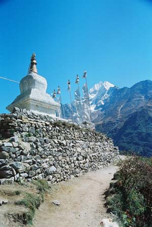
Namche Bazaar is a bustling hill town teeming with countless hotels. The streets are dotted with bakeries, souvenir shops selling everything from Sherpa artefacts to posters of Everest. Also, there are bookstores selling the latest mountain literature, mountaineering equipment stores selling and letting out equipment and of course Internet and satphone cafes.
To adapt to the rapid increase in altitude I decided to spend a day there. Next morning I headed for the Everest View Hotel, in Sagarmatha National Park, the highest national park in the world. Parts of the Himalayas and the entire southern half of Everest are within the park’s area. The park is unique in having four climate zones and is home to a wide variety of flora and fauna including the endangered red panda, snow leopards and the Himalayan black bear.
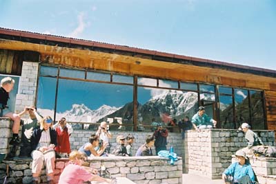
Everest View Hotel is the world’s highest luxury hotel. I followed a trail to the top of a ridge offering a grand view of the mountains including Mt Everest. Although hardly visible it was definitely a moment to cherish. The trail followed through lush green meadows and soon I was in the hotel.
Every room here gives a panoramic view of the Everest. After breakfast, I headed for the villages of Khumjung and Kunde. By late afternoon I was back in Namche Bazaar. The trail had been steep in some places, but you don’t need mountaineering equipment or even ropes.
I set off on the fourth day, through scenic pine country in the shadows of Ama Dablam, one of the most beautiful Himalayan peaks. I caught glimpses of Everest between the incredible Nuptse–Lhotse ridge. The trail initially climbed a bit and then descended steeply to the Dhud Kosi riverbed. After crossing the river, a steep ascent took me to Tengboche (also called Thyangboche), the largest monastery of the region, where I called it a day.
I woke up the next morning to the world’s most awesome sight — a panorama of the famed Himalayan giants Kwangde, Twache, Everest, Nuptse, Lhotse, Ama Dablam, Kantega and Thamserku.
After a short visit to the monastery I headed out. The trail took me past Deboche village and onwards to Pangboche where I had lunch. I continued along the trail through beautiful alpine meadows dotted with scrubs of juniper. Walking past the villages of Shomare and Orsho, I halted at Pheriche and decided to rest there for a day to acclimatise to the altitude — 4240m or 13,910.8ft.
On the seventh day the trail followed through beautiful meadows past the peaks of Twache, Cholatse and Lobuche. At Dugla, I crossed a stream on a rickety bridge and continued past the Sherpa Memorial (built in memory of the Sherpas who died on Everest) on to Lobuche. As soon as I checked in at the hotel, it started snowing.
It snowed all night and through the next morning, so I was left with no option but to trek in the snow. This trail passes the Khumbu Glacier and offers some of the world’s most dramatic mountain scenes. But the snow reduced the visibility to only a few metres. Luckily the trek was short and I was soon in the warm hotel room at Gorekshep.
Gorekshep has the last lodge en route the Base Camp — almost a three hour trek ahead. Surprisingly both Gorekshep and the Base Camp do not offer any view of Mt Everest. To witness Everest in its full grandeur one has to climb the rocky hill, Kala Pattar, just behind the lodge. But it was still snowing and I couldn’t climb Kala Pattar.
I don’t know how long it snowed that night. But at about 3:30am I peeped out of the window to see the spectacular peak Nuptse gleaming in the moonlight. Within an hour I was out on my way towards Kala Pattar, with the full moon showing me the way. Soon the south face of Everest became visible. The south face contains almost no snow and the black mass of Everest glowed in the silver moonlight. I reached the summit (5,545m or 18,192.3ft) well before sunrise. 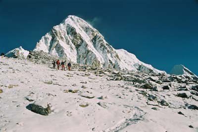
The sun rises just behind Everest, making a dramatic effect on unknown peaks of the west. Having my fill of that spectacular scene, I headed back. After a quick breakfast, I started for the Base Camp.
The route followed the Khumbu Glacier, passing through the foot of the Nuptse peak. Soon the notorious Khumbu Ice Fall, a near vertical wall of cascading glacial ice, became visible and so did the tents of the Base Camp. The skies were still clear and at that point I decided to head back to Kala Pattar the same day.
I reached just before sunset and this time it was fireworks on Everest. The setting sun turned the massif into a bright shade of crimson. It is a sight beyond the description of words. It can only be experienced, enjoyed and remembered forever.
Ready reckoner
Getting there: Kathmandu is well connected by air with various Indian cities. It is also well connected by road via the various border check posts. Lukla is well connected with Kathmandu by air. Royal Nepal and various private airlines operate flights.
Where to stay: Accommodation is available all along the trek route. Prices vary according to altitude.
Where to eat: Food is available all the way up to the Base Camp. Prices vary according to altitude.
Fitness factor: You only need basic fitness. A bit of jogging and freehand exercise before the trek can come in handy. No technical knowledge of mountaineering is required.
Photographs by author
|