On a rugged road
 A trip along the Silk Route to the Nubra Valley through Khardung La made for beautiful memories, says Rangan Datta WAYFARER A trip along the Silk Route to the Nubra Valley through Khardung La made for beautiful memories, says Rangan Datta WAYFARER
We really pushed the envelope going north, when we decided to head for Nubra. Jammu & Kashmir is India’s northernmost state, Ladakh its northernmost district and Nubra its northernmost sub-division. It’s connected to Leh, the district headquarters of Ladakh, by Khardung La (5,359m), the highest motorable pass in the world.
Our journey started from Leh, in a Tata Sumo. It was a clear morning and we were soon out of Leh. Looking back we could see the city, which appeared as a green oasis surrounded by a barren landscape. The road was excellent and we headed for Khardung La, our first stop.
As we approached the pass, the landscape became more rugged but the road was still great. Finally we reached the top of the pass — and what a place it was! We got down to admire the breathtaking view.
On the north was the Nubra Valley with the towering Sasser Peaks. On the south was the Indus Valley. The pass also has a temple — the highest in the world. There’s also a military base at the top of the pass and army jawans work round the clock to keep the road free from landslides and also provide every traveller with a cup of hot tea.
After getting our fill of beauty we descended from the pass into the Nubra Valley. The Nubra River is a tributary of the Shayok River, which in turn is a tributary of the Indus. The first village on the Nubra side is Khardung. The next village is Khalsar, which is the confluence of Nubra and Shayok.
At Khalsar our permits were checked and we stopped for a lunch break. From Khalsar there are two roads — the first follows the Nubra River
to Panamik and the other follows the Shayok to the villages of Hundar and Diskit. We took the first road, which took us past Sumur Village and onwards to Panamik.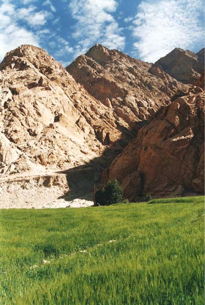
The route we were on was part of an ancient trade route, popularly known as the Silk Route. The route went all the way from India to Central Asia and Panamik was the last village on the Indian side. After Panamik, the road crossed the Karakoram and Kun-Lu ranges and went straight into Central Asia. So Panamik was the last settlement before the massive mountains, and traders used to halt a few days here to stock up supplies and make their final preparations for crossing the mountains.
We reached Panamik by afternoon and checked into a small shabby hotel. After that we went to the hot spring. Sadly it was poorly maintained and the area around the spring was very dirty.
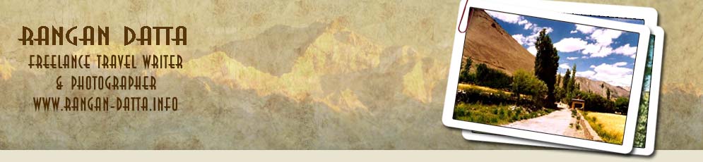
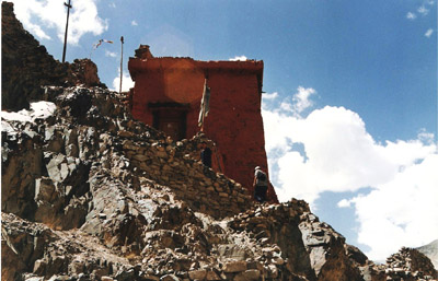
We quickly left the hot spring and wandered to the bank of the Nubra River (it’s also called Siachen Nala by the locals). The valley is really wide and is surrounded by barren mountains on all sides. But there’s a little bit of cultivation on both sides of the river. The combination of barren brown mountains, white foamy water and green fields is a truly beautiful mix. Just on the other side of the river was the small Ensa Monastery.
Next we moved on to see the famous Panamik granaries, which once served the traders of Central Asia. It was a sad sight; the age-old granaries have been modified, and serve the Indian Army now. Today Panamik is a small village and a ghost of its former self. It’s hard to believe that once traders from all over Asia crowded its lanes and bylanes.
Continuing our journey, we left Panamik the next morning and headed for Hundar. We continued along the same road to Khalsar, from where we took another road that heads towards Diskit and Hundar. At Hundar there’s a bridge marking the end of northward travel.
Just before the bridge, by the side of the road, is the Hundar Monastery. On the other side there are several structures high up on the mountain. We climbed the hillside to look at the structures, which turned out to be small shrines dedicated to Buddha. High above this there was a huge structure completely in ruins which appeared to be an ancient fort.
After seeing the monastery we headed for the sand dunes of Hundar. We went up and down the dunes looking for suddenly elusive Bactrian camels. These camels have double humps and are much hairier than their Arabian cousins. This is the only place in India where these double-humped camels — which once carried loads along the Silk Route — are found. Today the trade has stopped and the camels have been domesticated and are kept by the villagers. There’s a breeding centre in Diskit as well.
We finally gave up our search for the camels and headed for Diskit, which is the headquarters of Nubra sub-division and a small town in the mountains. It has all basic facilities including a number of good hotels. Just above the town is Diskit Monastery, a huge structure with units built one above the other in pyramidal style. We spend quite a lot of time exploring the different sections of the monastery, and the lamas were kind enough to explain every detail. We spent the rest of the evening exploring the town.
Next morning we went to the breeding centre to have a look at the Bactrian camels. We finally saw the camels — though they were resting in a shed. And then it was time to return. We followed the same route back to Leh, thus ending our journey to India’s far north.
Ready reckoner
Getting there: Leh is connected by air from Delhi, Chandigarh, Jammu and Srinagar. It is also connected by road from Manali.
Permits: Indian nationals need an Inner Line Permit to visit Nubra. Hotels in Leh can arrange for permits as well as vehicles.
Photographs by author
|